Soil Surveys, Environmental Assessment & Land Management
Land Research - Case Study
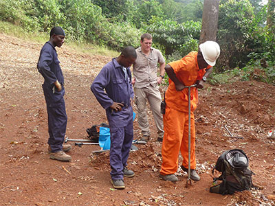
Eastern Liberia iron ore project
The Putu iron ore project is a 13 km long iron rich ridge within a 425 km² exploration tenement, located 130 km inland from the eastern coast of Liberia. It represents one of the largest iron ore reserves in the world, having estimated reserves of 4.4 billion tonnes of ore, with an average 34% iron grade.
LRA was asked to produce a reconnaissance soil map of 132 km2 of degraded tropical forest and shifting cultivation land as part of a pre-feasibility soil geochemical study for the mining project. Working with a Schlumberger Water Services scientist and local staff, and operating out of a mining camp in a guarded stockade next to Putu ‘Town’, the work involved undertaking soil survey transects across different land ‘facets’ of Putu Mountain and adjoining foothills. Training in soil sampling techniques was also provided for the local technical assistants.
Six main soil types were delineated, typical profiles of each were described and photographed, and samples of each soil horizon were sent for laboratory analysis. A reconnaissance soil map was produced in LRA’s GIS with the help of detailed geo-referenced aerial photography flown at the same time as the survey. The map was submitted to the client with an explanatory report.
In July 2016 a Class “A” Mining License for the mining of iron ore in the Putu Mountain Range was granted to Putu Iron Ore Mining Company Incorporated (a subsidiary of OAO Severstal) by the Government of Liberia.
LRA are experts in soil survey for a variety of mining and quarrying projects. If you have a similar project you wish to discuss, or have a related enquiry, please contact Mike Palmer on +44 (0)1509 670570 or mike.palmer@lra.co.uk.